RAINBOW SPRINGS FIRE
INCIDENT COMMANDER NARRATION
Given February 1997 for use in the Fatality Fire Case Study Training Course
Fire Narrative
Upon our arrival at the fire around 1345 hours, the District Ranger
told me to take charge of the fire. Sizing up the fire was relatively simple.
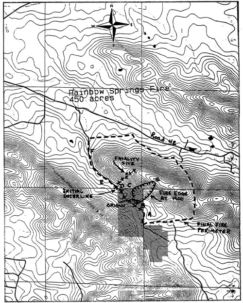
From point A (see attached map), I had an excellent view of the fire. The
head fire had just reached the mountain top and the overall intensity was
diminishing rapidly. Flames on the left flank were being pushed by a strong
southeasterly wind but flame heights were generally less than 2 feet. The
rate of spread was approximately 8 chains per hour on the left flank, but
as you will see later, the rate of spread was greater along the lower portion
of the south facing slope due to lens surface rocks and a much larger accumulation
of surface fuels (pine needles and hardwood leaves).
I considered a number of options but never considered a direct attack on
the left flank because of the steep terrain and wind gust up to 30 MPH from
the southeast. It was also my feeling that the terrain was too steep for the
tractor not to mention the inexperienced operator. I was not really concerned
about the head fire that had already reached the top of Dallas Mountain and
perhaps started down the north slope. The overstory vegetation on the north
slope was hardwood with only surface fuels consisting of cured hardwood leaves.
The fire would also be backing down the very steep slope that was largely
shielded from the strong southeasterly wind. My main concern at that moment
was the left flank since the wind was pushing the fire in a westerly direction
down the south facing slope of Dallas Mountain.
As I recall, the District Ranger, ORA, Timber Sales Administrator, Tractor
Operator and I were the only arrivals. The District Silviculturist was in
route. Soon after our arrival a member of the volunteer fire department for
the community immediately north of Dallas Mountain arrived on the scene. He
informed me that the fire was already burning down the north slope of Dallas
Mountain and also informed me that the people with homes along Road 42 were
already in a state of panic. I radioed the District Silviculturist who was
in route and requested that he drive west on Road 42 and see if he could locate
a route into the fire from the north and also give me a report on how far
the fire had progressed down the north slope of Dallas Mountain. He reported
back a few minutes later that crews coming in from the north would have to
travel by foot from Road 42. At the same time, he reported the fire had made
little, if any, progress from the top of Dallas Mountain down the north slope.
Although that news was reassuring, my brief conversation with the local fire
department volunteer had brought back some horrors of the Acorn Fire in which
I had to deal with home owners in panic at the same time I was attempting
to direct operations on the fire. I certainly did not want the fire to reach
the residential area along Road 42 and that sense of urgency most likely influenced
some of my decisions.
Click for larger
image.
At about 1400 the Poteau Ranger District Tractor Crew was dispatched to the
fire. I was expecting a let of handline construction on the north side of
Dallas Mountain and had requested an additional 50 firefighters for handline
construction and burnout.
My plan of attack was to use our tractor to clean out a primitive road from
Point B to Point F and then construct a tractor line around the west end of
Dallas Mountain from Point F to the ridge top. In the meantime, I would let
the hand crews walk around the right flank of fire to somewhere around Point
G. They would anchor to the fire at that point with most of them working west
with a handline and doing burnout at the same time. A smaller number of them
could work back along the right flank. However, the fire on the right flank
was moving very slowly into the wind and I did not consider that a priority.
Again, my main concern was the fire moving west along the south slope of Dallas
Mountain which I refer to as the left flank. However, due to wind direction
and terrain, that could have logically been called the head of fire.
At about 1415 our tractor crew had started cleaning out the primitive road
moving west from Point B. Our new Timber Sales Administrator was leading the
tractor but had not been red carded or even received any training for tractor
boss. The District Ranger and ORA were serving as line scouts. AT 1510 the
Poteau Tractor crew arrived with Paul Keener as tractor boss and James Frizzell
as tractor operator. At the time they arrived, I did not know where to send
them. I had a scout checking the right flank of the fire to see if they could
operate in that area. A few minutes later that scout informed me that he did
not feel the tractor could work the right flank due to rocks and steep terrain.
In the meantime, the Mena Tractor Boss informed me that the Poteau tractor
could work in his area. I directed Keener to take his tractor down the freshly
bladed road (left flank) until he made contact with the Mena Tractor Crew.
It was only a few minutes later however at about 1521 when the Timber Sales
Administrator informed me that they had reached the mountain top with the
tractor line. I recall being very surprised that they had made that much progress
in the relatively short time period he had been working on the line. Although
we did not have a topo map at the fire, I had estimated the distance to the
west end of Dallas Mountain to be about 1/3 mile from where they started at
the origin of the fire. I thought the mountain dropped off at about the letter
D (in Dallas) on the attached map. I made that assumption because from my
location at Point A the ridge top appeared to be dropping off. I was also
using my memory of where the mountain ended from my travel of the primitive
road at a much earlier date. Unfortunately, the drop off was into a saddle
and the actual distance to the west end of Dallas Mountain (Point F) was closer
to 1 mile. Had I been aware of the longer distance, I may have called for
the tractor line to be located in the same general area that it was located.
However, I would have been very concerned about having people on the steep
south slope working that close to the main fire, hopefully my actions would
have reflected that concern. With that approach it would have been extremely
important that the tractor line be anchored to the fire at the top of mountain
and the line be constructed downhill with a very timely burn—out of
that line. I would have also made certain the line scouts were closely monitoring
the main fire. Whatever the strategy, I had very serious concerns about any
of our people working the steep south slope in unburned fuels on the left
flank of the fire. I spent the entire afternoon from initial attack until
the accident thinking that none of our people were working in those conditions.
When I received word from the Timber Sales Administrator that they had reached
the mountain top with the tractor line, I did not question their progress
or the actual location of the tractor line. Instead, I told him to start the
burn—out moving slowly back down the tractor line. Moments later he
called to inform me that the backfiring torch was not on the tractor and no
one had thought to bring a torch or any other firing device.
The employee under investigation that I mentioned earlier had joined me at
Point A. Although he showed signs of mental stress and did not appear to be
in good physical condition, he had passed the step test and was technically
a qualified firefighter. Since no one else was available, I gave him a drip
torch and told him to take it to the Timber Sales Administrator. From what
I was told later, he stopped to rest several times along the way and did not
reach his destination in a timely manner, but as it turned out, that may have
been a blessing. Had he delivered that torch only a few minutes earlier it
could have brought additional people into the blow-up site adding to the number
of fatalities or serious injuries.
Most of the hand crews had arrived at Point A around 1530. Instead of sending
them around the right flank as previously planned, they were told to use the
tractor line and join up with the District Ranger and Timber Sales Administrator.
The plan was to use some of them to burn out and hold the tractor line on
the left flank but the majority would be used to construct and burn out a
hand line working east from the tractor line that ended at the ridgetop. That
line would completed a line around the fire and hopefully provided containment.
At about 1605 our fire detection aircraft flew over the fire and the aerial
observer told me the fire had cooled down considerable from the time he had
observed it earlier in the afternoon. That received some discussion during
the subsequent investigation and review but the information from the aerial
observer had nothing to do with my decisions. I knew the weather conditions
had not changed and could see no reason to be complacent. The aerial observer
was not a fire behavior officer and I did not feel he had the knowledge and
experience to accurately evaluate the fire.
At 1610 the District Ranger informed me that he had scouted the right flank
of the fire and felt the tractors could be used to construct part of that
line. I called the Poteau Tractor Boss and requested that he bring his tractor
back down the tractor line to my location at Point A. From there he would
receive further instructions.
What I was not aware of was an incomplete section of tractor line at the
fatality site (see attached map). One of our employees told the Poteau Tractor
Boss to connect that section of line on his way down the mountain. That action
held them up at the fatality site.
At about 1620, a member of the local volunteer fire department was located
at Point E and observed a spot fire at Point D that he later described to
be about 1/2 acre in size but spreading rapidly up slope toward the fatality
site. He had no radio communication with Forest Service personnel but would
not have known what was about to happen anyway. The spot fire moved rapidly
up slope until reaching the area of preheated fuels. The influence of the
mountain saddle resulted in a much higher wind velocity in that same area.
The blow-up immediately south of the saddle as shown on attached map was so
intense that it is difficult to describe. I was alerted by the very loud noise
even as far away as Point A. It was very frightening to me although I had
no idea the Poteau Tractor Crew members, Paul Keener and James Frizzell, were
directly in its path. There is no way to describe the feeling that came over
all of us when their bodies were discovered a few minutes later.
As indicated earlier, the rate of spread was much greater along the lower
part of the south slope. The fire had moved to Point C probably around 1615
and it is likely that a very strong gust of wind carried a burning ember all
the way to Point D. We had an Ignition Component of 78 but did not know that
until after the fact. However, had there not been a spot fire, the main fire
had already reached the base of the canyon located immediately east of the
fatality site. It would have been only a matter of minutes until that fire
made a run up the canyon with the same consequences, or worse. It could have
been worse because the burn-out operation was getting ready to start. That
would certainly have brought more people into the area. We should also remember
that the hand crews used that same tractor line to reach the north side of
the mountain only a few minutes earlier. As terrible as it was, it could have
easily been much worse.
<<< continue
reading Rainbow Springs Fire, Lessons Learned >>>
|